


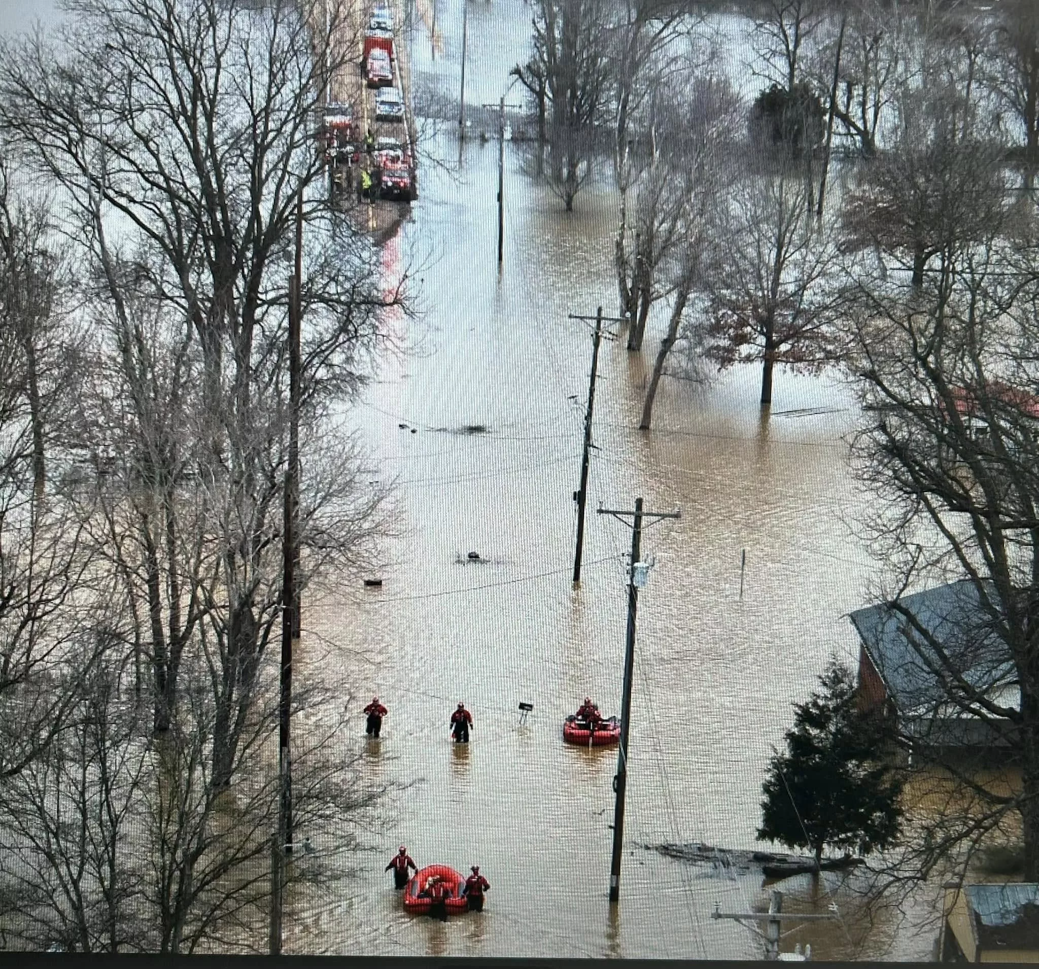
Union City, Tenn.–Obion County Emergency Management Agency Director Danny Jowers has issued a statement regarding last weekend’s situation in Rives, at which flooding caused numerous evacuations and water rescues. He thanked all first responders and volunteers who pitched in to help in a frightening situation.
“Once the levee was topped,” he said, “the pumps were stopped the decision was made to evacuate due to the potential complete levee failure. Had the levee completely failed the entire town would have been swept away within minutes as millions of gallons of water would have entered unchecked.”
Jowers’ statement:
“Hopefully I can explain what actually caused the flooding and subsequent evacuation of Rives. Extreme rainfall over a broad area fell during Friday and Saturday.
“Rivers to the south of Rives were already at flood stage long before this rainfall event. Precautions for Rives were already in play as Mayor Burns acquired two large pumps to take care if water inside Rives. Saturday afternoon the pumps were on we could drive pretty much anywhere we wanted and frankly thought everything would be fine until 5am when I was asked to bring resources into Rives for evacuation.
“So what happened?
“## During the night water began overlapping the east levee which runs from the fire station north. This levee which is an old railroad bed protects Rives from Hoosier Creek and waters from the North Fork Obion River which is to the east of Hoosier Creek.The first picture attached is the fire station and the levee running north and Hoosier Creek. Note the levee runs north connecting to the CN railroad which serves as a,continuous levee protecting Rives to the east The railroad itself was never toppled as train traffic continued. The second attachment is a broader view to the north of Rives. North of Rives several other creeks converge with Hoosier Creek. Google map mislabeled one of these creeks Obion River. The third attachment shows the actual North Fork Obion River. Please also note there is no levee to protect Rives from flood waters on the west side of Hoosier Creek when it overflows. As water enters Rives from the Northwest. normally pumps inside Rives can pump this water back out. The problem came as the water overlapped the east levee. This is a definition of overlapping. This refers to when water flows over the top of a levee without necessarily causing a full breach, but can still lead to erosion and potential failure if the overtopping persists. The cause of the overlapping was the tremendous amount of water flowing from the northeast and from breaches along creeks north of Rives and breaches along the North Fork Obion River. There are videos and photos showing a large breach of a waterway somewhere in this area. We know the Obion River system breached in numerous places south of Rives. To be frank the North Fork became an ocean in this area The exact location of that breach is not known. What is known is that the east levee of Rives was overlapped and DID NOT cut into for a levee failure.
“## Once the levee was topped, the pumps were stopped the decision was made to evacuate due to the potential complete levee failure. Had the levee completely failed the entire town would have been swept away within minutes as millions of gallons of water would have entered unchecked.
“## Potential solutions is a permanent large stationary pump inside the levee and some type of protective barrier the the northwest of Rives to protect it from waters overflowing from Hooiser creek. Remember this Creek carries water all the way from northwest of Union City. Another area to be looked at is where the east levee meets the railroad
“## I fully support all decisions made during this event and also support a better solution for this community. No lives were lost!! But the potential loss could have been catastrophic. Thanks to ALL who responded!!”
Photos: Evacuations in Rives. Madison County Fire & Rescue photo.