


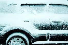
Murray, Ky.–Calloway County and other counties in west Kentucky could be directly in the path of an arctic cold front in winter storms throughout this week.
The Calloway County Sheriff’s Office issued a weather alert early this morning which calls for arctic temperatures, two inches of snow today and from 4-8 inches of snow throughout the day Monday, followed by more snow through the week:
“The first storm is set to be here Sunday, February 14th. Snow showers will begin as early as 8 pm. The snow will continue overnight and into early Monday morning. Accumulations will begin sticking immediately due to the cold temperatures and total up to 2 inches by sunrise. After a possible short break, the winter storm picks back up around noon Monday, February 15th. According to local news, snow will fall at a rate of up to 1 inch per hour through midnight. Meteorologists are calling for 4 – 8 inches of snow accumulations throughout the day. There will be isolated areas that could see double digits. Road crews will find it very difficult to keep up with the winter storm.
“With the high probability of this winter storm occurring, driving conditions will be severely affected as road conditions deteriorate rapidly.
“The Calloway County Sheriff’s Office strongly urges that travel be limited to necessity and emergency during this inclement weather event. Sheriff’s Deputies will be responding to emergency calls and helping others while road crews will be out plowing the roadways. We ask that everyone be prepared at home with plenty of food and water. Be sure that all of your loved ones are also prepared and cared for. Temperatures will be in the low teens to single digits with wind chills around or below zero. Make sure that pets and livestock are also not in harm’s way.
“A second round of winter weather is supposed to set in Wednesday/Thursday which could bring a heavy wintery mix or an additional several inches of snow. It is too early to tell exactly what that storm will bring at this time.”