


Kentucky Transportation Cabinet (KYTC) District 1 Snow-Fighters are taking on some brutal weather conditions in an effort to clear snow from area highways.
A morning temperature of 9 degrees at Paducah and a wind chill of -6 degrees kicked off what is expected to be a tough week. Many of our District 1 counties had 1 to 2 inches of snow during the overnight ours. A break is expected this morning with the heaviest rounds of snow expected this afternoon. The afternoon could bring accumulation amounts of an inch of snow an hour with 15 mile an hour winds creating near-blizzard conditions.
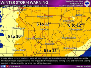
The National Weather Service Winter Storm Warning indicated between 6 and 12 inches of snow accumulation by Monday night (See attached graphic). The NWS forecast suggests that the region will experience major to near-impossible travel conditions. For more information go to https://www.facebook.com/
The District 1 Snow & Ice Team is joining the NWS in alerting the public to the potential for travel disruptions across the region if the snow accumulation trends toward the higher numbers.
While accumulations are expected to be significant, due to cold temperatures the snow is expected to be fairly light and fluffy making it easier to plow. However, with 10 to 15 mile per hour winds, it could also create the opportunity for drifts to develop that may further hamper travel.
Highway crews are focused primarily on “A” Snow Priority Routes- which include Interstates, Parkways, U.S. Highways, and some other 4-lane routes. For a complete county-by-county snow and ice priority list please go to: https://transportation.ky.gov/
Highway crews will go on a 13-hour shift rotation for the remainder of the week with shift changes at midnight and noon each day. In addition to the KYTC District 1 plow fleet, about 20 contract trucks are on the road.
The Kentucky Transportation Cabinet is working with the Kentucky State Police to expedite the removal of abandoned vehicles along the shoulder of area highways to prevent them from interfering with snow removal operations.
KYTC engineers continue to remind everyone that extra caution is required during extreme cold temperatures. The low Monday night is expected to be around 9 degrees with a wind-chill around zero or below. It all adds up to some brutal working conditions for District 1 Snow-Fighters and very difficult driving conditions for the public.
After a brief reprieve on Tuesday, another strong winter weather system is expected to impact the region Wednesday through Thursday evening. This system will bring another round of snow to the area. Confidence is high that we could see multiple inches of snow with this second snow event. Stay tuned to the latest forecasts as updates are inevitable this week.
Cold weather is also going to stay with us into Friday. Some help is expected by the weekend with highs above freezing expected by Saturday.
Real-time travel conditions are available at goky.ky.gov or via the WAZE APP.